Tornadoes: The Science Behind Them
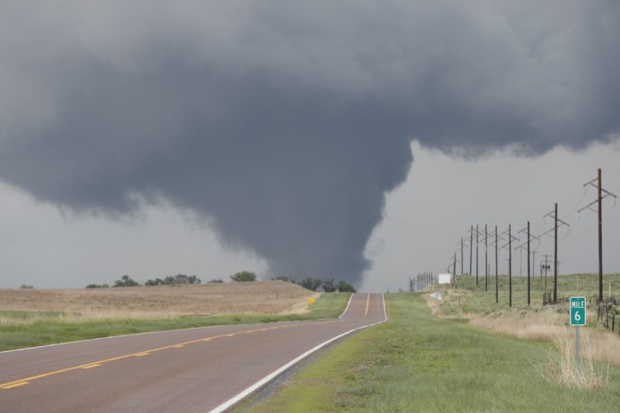
Jason Frederick via National Weather Service, Public domain, via Wikimedia Commons
A tornado in Nebraska in 2021. No injuries or deaths were reported as a result of this tornado.
What is the definition of a tornado? How is a tornado formed?
The National Severe Weather Laboratory on its website defines a tornado as “a narrow, violently rotating column of air that extends from a thunderstorm to the ground.”
Tornadoes typically spawn from a supercell thunderstorm. These types of thunderstorms, and the possibly subsequent supercell tornadoes, are formed by a rotating updraft. This rotating updraft can be caused by wind shear, which occurs “when winds at two different levels above the ground blow at different speeds or in different directions,” as explained by the National Severe Storms Laboratory website. Although the rotating air originally rises horizontally, if the rising air tilts it vertically and humid air at ground level mixes with this now-vertical column of rotating air, there is a possibility for a tornado to form.
Most tornadoes form from supercell thunderstorms, but some do not. Instead, non-supercell tornadoes form from vertical, spinning air that is near the ground. This spinning air is caused by the windshear from a cold, warm, or seabreeze front, or from a dryline (a boundary that separates dry and moist air), for example. If an updraft moves over this vertical, spinning air, then there is a possibility for a tornado to form. These types of tornadoes are much less dangerous than supercell tornadoes, as they typically form over less-populated areas (such as Eastern Colorado, where the Rocky Mountains’ cool air mixes with the plain’s hot and dry air).
How is the intensity of tornadoes rated?
In 2007, the Enhanced Fujita scale replaced the original Fujita scale because it was determined to be more accurate than its original version, since “[t]he EF scale incorporates more damage indicators and degrees of damage than the original Fujita scale,” which allows for “more detailed analysis and better correlation between damage and wind speed,” as explained by the National Weather Service on its website. (The original Fujita scale was created by a Japanese-American meteorologist in the 1970s, after whose last name the scale is named.) The Enhanced Fujita scale rates tornado intensity from zero to five – an EF0 tornado has wind speeds of 65 mph to 85 mph, an EF1 tornado has wind speeds of 86 mph to 110 mph, an EF2 tornado has wind speeds of 111 mph to 135 mph, an EF3 tornado has wind speeds of 136 mph to 165 mph, an EF4 tornado has wind speeds of 166 mph to 200 mph, and an EF5 tornado has wind speeds over 200 mph.
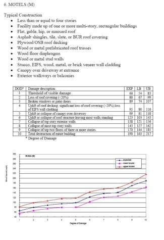
To determine the intensity of a tornado, trained personnel from the National Weather Service use both damage indicator (DI) and degree of damage (DOD) charts. The National Weather Service explains on its website that its personnel will first “identify the appropriate damage indicator…from more than one of the 28 used in rating the damage,” such as a transmission line tower or motel. Once the personnel have identified the correct damage indicator, they then use the degree of damage chart to corroborate the observed damage. Each damage indicator has at least eight degrees of damage that must be considered when evaluating the intensity of a tornado. These degrees of damage range from visible damage to absolute destruction of the damage indicator. For example, if National Weather Service personnel were examining damage to a motel, then they would find “motel” listed on the damage indicator chart. They would then corroborate the observed damage by examining the degree of damage chart to see what degree of damage corresponds to the damage they observed.
At this point, tornado evaluators “will then make a judgment within the range of upper and lower bound wind speeds, as to whether the wind speed to cause the damage is higher or lower than the expected value for the particular DOD [degree of damage],” as explained by the National Weather Service explains on its website. (Upper and lower bound wind speeds are simply the minimum and maximum wind speeds that correspond to each Enhanced Fujita scale rating; for example, an EF3 tornado has wind speeds of 136 mph to 165 mph, so its lower bound wind speeds would be 136 mph and its upper bound wind speeds would be 165 mph.) Noting this, if the top exterior walls of a motel collapse from a tornado, then the tornado would likely be considered an EF3 tornado, as the expected wind speeds are 138 mph for this degree of damage, which falls into the parameters of an EF3 tornado’s wind speeds. Before reaching a final Enhanced Fujita scale rating, however, the National Weather Service personnel will examine several similar structures using this same process.
To read about tornado facts and safety tips, check out this article!
Philip is a senior from the Washington, D.C. area. In his free time, he enjoys writing, singing, traveling, and photography.